
2019 – DriTri @ USNWC
Personal collective of ideas, thoughts and notes


LendingClub is a US peer-to-peer lending company headquartered in San Francisco, California, and has helped over 2.5 million customers simplify their finances in the last 10 years. LendingClub improves the loan process for borrows by offering a fast and easy online application. For investors, the company offers historical returns of 3 – 8% and anyone can invest with as little as $1000 [1].
Because LendingClub relies heavily on technology to evaluate their borrowers, getting an accurate risk analysis for each applicant requires systems which can quickly assess the applications, and upon approval, offer these loans to interested investors at a given interest rate. Of the $7.9 billion dollars loaned in 2018, $233 million was written off as defaulted loans. While this may seem insignificant at 2.9%, this does represent risks and losses which investors and the company would prefer to avoid. In order to mitigate risk, lending companies traditionally apply a fitting interest rate to each loan. For example, loans for a home or a car may have lower interest rates because the risk is reduced due to directly related collateral. In another example, someone with a poor credit history or having declared bankruptcy may have a higher interest rate due to the inherent risk of history repeating.


First time dipping my toes into off-road “triathlon” … (SUP, MTB Ride, Trail Run)

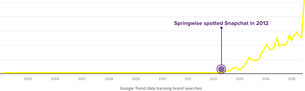
If there has been one email/newsletter I am excited to receive monthly, its from a company called Springwise. They share innovative and creative ideas from around the world. It’s a great resource to find inspiration or follow emerging trends which you are interested in. A prime example: Snapchat 🙂
You must be logged in to post a comment.